| |
|
|
|
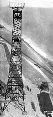
The prototype CH system - Chain
Home Low (CHL)
Virtually all of the south and east coasts were covered by a new
set of stations. The new CHL system used the same 'filter rooms'
arrangements as CH and they were fully integrated with each other
in 1940, just in time to cope with the Battle of Britain. The range
was always less than the CH system could manage but in contrast,
the altitude information was now accurate down to 500 feet. Thus
the two systems complemented each other. The shorter wavelengths
meant that smaller aerials and lower masts had to be employed. Even
mobile units could be constructed. Aerial improvements continued;
a single transmitter / receiver unit was devised so that it was
no longer necessary to use two separate devices.
|
Professor G. E. Bacon
|
Mr A. E. Bennett
|
|
|
|
|
|
|
|
|
|
|
|
|
| A further refinement
was that the aerials could now be rotated at a steady 3 rpm
and the resulting plot could be displayed using another invention;
the 'plan position
indicator' (PPI). This device produced a rotating scan and
then a scaled map could be overlaid to give a far better indication
of aircraft location, at least in the horizontal plane. At this
point, the practical implementation of an effective Ground Controlled
Interception (GCI) network became a reality. From 1941, it was
now technologically possible to adopt a 10 cm format that had
specific applications for the Army and the Navy because it made
lower- looking, surface-based radars possible. These systems
were known as CHEL (Chain, Home, Extra Low).
|
|
|
|
|
|
|
|